![]()
![]()
Reef Ball Project off Ogden Point
Marine Mammal Monitoring Program M3
2000 Times Colonist International Gorge Waterway Swim Event
How to build an under water ROV by Bob Truelson
Plants, Species, Watershed Planning, Fish & Wildlife, Tress , Shrubs
Education Program Water Quality
Ganges, Salt Spring Island Beach Cleanup
Pictures of the Robertson II Set 1
The Veins of Life Watershed Society began in 1994 as a father, John and son, Wesley, cleanup effort on the Gorge waterway in Victoria, BC. The debris removal campaign quickly gained momentum, and in 1996 a core group of active and interested volunteers registered VOLWS as a nonprofit society.
The Veins of Life Watershed Society (VOLWS) is a community-based conservation organization operating in the Salish Sea which includes parts of Vancouver Island, BC.
VOLWS focuses on a watershed-based approach, and initiates habitat restoration projects, shoreline & stream garbage removal, environmental education programs and public outreach activities.
The goal of VOLWS is to establish a healthy and sustainable environment in which watersheds support fish and wildlife, and recreational use. Goals are achieved through consultation and cooperation with government agencies, businesses, local environmental groups and the public.
![]()
Phone # 250 383 2086
Priorities:
Enhance the Storm Water Monitoring Program and create a Storm Water Utility that encompass the Gorge Waterway / Victoria Harbour Watershed
Create a Gorge Waterway / Victoria Harbour Watershed Conservation Authority to protect and enhance our natural environment.

Above is the Gorge Waterway/ Victoria Harbour Watershed Victoria, BC , this area encompasses Victoria Harbour starting at Ogden Point, Inner Victoria Harbour, Selkirk Waters, Gorge Waterway, Portage Inlet, Craigflower Creek, Colquitz Creek and several tributaries. Our Watershed is shared with the SongHees Nation,Esquimalt Nation, City of Victoria, Township of Esquimalt, Town of View Royal, District of Saanich, District of Langford, District of Highlands, District of Central Saanich.
Conservation Authority for the Gorge Waterway / Victoria
Harbour Watershed
Population = 247,482
4 Chief
6 Mayor
63 Council
1) Integrated Storm Water / Sewer Utility
2) Protect and Enhance our Farming Infrastructure
3) Protect and Enchantment of our Fisheries, Bird and Wildlife
4) Preserve / Protect / Increase our Industrial Lands within our Harbour's
5) Establish a Victoria Harbour / Gorge Waterway Conservation Authority
6) Adopt and manage our watershed with ISO 14000 family - Environmental
management System
7) Integrate all Parks under one Conservation Authority
Tsartlip First Nation : 921 1 Chief and 9 Councilor
Tsawout First Nation : 789 1 Chief and 8 Councilor
Esquimalt First Nation : 250 1 Chief 4 Council.
Songhees First Nation : 528 1 Chief and 5 Council.
District of Central Saanich : 16,814 1 Mayor and 5 Council
District of Highlands : 2,225 1 Mayor and 6 Council
District of Saanich : 113,624 1 Mayor and 8 Council
Town of View Royal : 10,408 1 Mayor and 4 Council
Township of Esquimalt : 17,655 1 Mayor and 6 Council
City of Victoria: 84,289 1 Mayor and 8 Council
Population = 247,482
4 Chief
6 Mayor
63 Council

Where did the name Veins of Life Watershed Society come from? When the discussion about the formation of a non-profit was being bantered about the discussion of a name came about. My Daughter, Tracy was looking at a Boucher published by , at that time MELP ( Ministry of the Environment BC ) in the right side of the publication was the above picture ( excuse the quality ). The picture shows the area of BC now called The Salish Sea, the red lines throughout the drawing indicate the lost salmon producing streams on the east side of Vancouver Island, and the West Coast of British Columbia. My Daughter said if you looked at the drawing it looks like the arm of a man and the red lines look like blood veins, and the name of the organization was born Veins of Life Watershed Society.
![]()
RE-INVENTING
RAINWATER
MANAGEMENT:
A STRATEGY TO PROTECT HEALTH
AND RESTORE NATURE IN THE CAPITAL REGION
By Gordon McGuire with Neil Wyper, Michelle Chan,
Adam Campbell, Scott Bernstein and Jill Vivian.
Supervised by Professors Deborah Curran and Calvin Sandborn
Editing and Layout by Holly Pattison

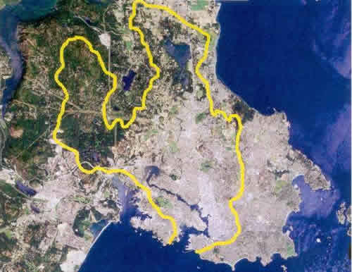
Above is the Gorge Waterway Watershed Victoria, BC , this area encompasses Victoria Harbour starting at Ogden Point, Inner Victoria Harbour, Selkirk Waters, Gorge Waterway, Portage Inlet, Craigflower Creek, Colquitz Creek and several tributaries. Our Watershed is shared with the SongHees Nation,Esquimalt Nation, City of Victoria, Township of Esquimalt, Town of View Royal, District of Saanich, District of Langford, District of Highlands, District of Central Saanich.
The population of the watershed is approximately 247,482. The area is a mix of commercial heavy and light, farming industrial and light, shopping center's, and residential.
You will probably notice from this satellite picture that like everywhere else in North America we have managed to cut down our trees and pave it all over, and we ask our selves why is there no salmon, where did all the birds go?
Your government will tell you it's economics, how do they define economics, well bulldoze the trees, level the hills and we will prosper.
REMEDIATION & PLANNING of VICTORIA HARBOUR, GORGE WATERWAY & PORTAGE INLET:
What do you want the Victoria Harbour, Gorge Waterway & Portage Inlet to look like in one hundred years. Should we now begin the process of creating an urban park for when our population crawls over one million people or more.?
Should we design an urban park along our shores, buying and removing existing housing over a period of years?
Climate change is very real, our oceans are rising, homes and land through out our watershed are already flooding, in less than one hundred years the Harbour and Gorge Waterway will increase in rise 1.3 meters on normal high tides, under the right conditions with the winter Pacific storm's, the Colquitz and Craigflower Creeks are all ready at their maximum flows, with no where to go. Waters will rise up too or exceeding 3 meters. Do we build dikes and further decimate what habitat we have left, or do we buy and tear down the existing developments and let nature take it's course. Over 25% of the existing homes and lands will be flooded, and rest assured those that lose their property and belonging's will be at the government coffers to bail them out, It's cheaper in the long run to buy them out and deal with it now in the next twenty or so years.
Should we have no go areas where birds and marine mammals have a rest and breeding areas where they are not disturbed.
Take a look at the shoreline along our Harbour and Gorge, the only place left natural is at the Point Ellice House, even today the remedy seems to be rip-rap with out any opportunity of natural propagation, insert the rock without soil, turn our Harbour and Gorge into one big culvert like the Frazer River and then pat yourselves on the back, plant some pretend trees, go home and enjoy your lives.
We as a community can build for the future, we just need to dream and just do it.
For those that are interested, we are following up on a project that the Veins of Life Watershed Society and The Gorge Waterway Society initiated in 1996. At that time we filmed and surveyed the entire shoreline in the Municipality of Victoria, Esquimalt, View Royal and Sannich. This was to establish a base line of changes along our Waterway, at that time because of the success of the community projects the Gorge Watershed became popular again, since then a number of modifications to shoreline and docks where added without the proper permits from the various levels of Governments.
It is our intent to continue to seek enforcement of our regulations, those that have gone through our community process, have done the proper science and obtained all the permits necessary, have our whole hearted support and a thank you. Those that did not get the necessary permits & ignored our laws will be publicly identified and reported,
Interesting report commissioned by the Gorge Waterway Action Society in 1994 at lot of the work done by the VOLWS was first developed from the ideas and wishes expressed in this report, it's a good read, what is written is applicable today very little progess gained.

1) Your Riparian Rights In BC 2009 Riparian Rights and Public Foreshore Use in the Administration of Aquatic Crown Land